分享图标


Satellite Shooting Demo

The satellite is collecting images


OMAP Profile

Beijing O-MAP Geographic Information Technology Ltd.(short for “OMAP”)is a well known satellite imagery data suppiler,located in Beijing, China。 OMAP offers high resolution remote sensing imagery data, satellite imagery data including historical imagery data taken by KeyHole satellite from 1964 to 1984, 、the TM and ETM+ data taken by Landsat from 1980 to 2000, and Maxar satellites since 2000 to now,AirBus satellitesChinese remote satellites such as GF2 satellite and GF1 satellite、 South Korean Kompsat satellites、Chinese SueprView satellite and Jilin satellites. These data all are high resolution satellite images, mainly collected between 2000s to current year,the satellite names are:

1、America Maxar satellitesIKONOSQuickBirdWorldView1WorldView2GeoEyeWorldView3WorldView4
2、France AirBus satellitesSPOT5SPOT6PleiadesPleiades-NEO(PNEO)
3、Chinese SatellitesSuperViewGF2GF1GF6GF1-BCDJilinZY seriesGF3 radar satellite
4、South Korean Kompsat SatellitesKompsat2Kompsat3Kompsat3AKompsat5 radar satellite
5、otherremote sensing satellitesBlackSkyALOS2TerraSARGF7PlanetSentinel2ALandsat(MSS/TM/ETM/OLI)、KeyHole

Satellite imagey is sold by area or scene,the price of the satellite imageryis about 1RMB、10RMB、30RMB、50RMB、100RMB、200RMB、400RMB per squre kilometers,and the price is effected by data resolution, data date, data type, product type and processing level, please contact us to get the accurate price for your project。 satellite imagery data is a kind of special digital product, anyone or any departments are available and legal to purchase satellite images, we can offer the formal sale contracts and invoices ,you are about to get data in at least 5 working days and at most 10 working days after you fininsh the payments.

To get help or purchase satellite imagery please contact us or leave online messages to us。


Satellite Image

高分辨率卫星拍摄的遥感影像图

01.Archived Data

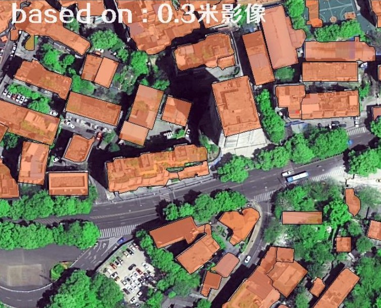
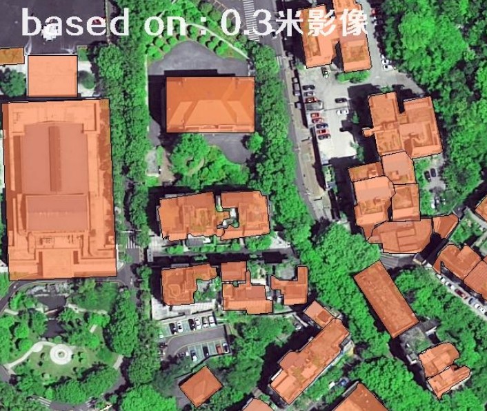
Our company brings together major global commercial high-resolution satellite companies such as the United States, France, South Korea and China's commercial satellite resources to provide you with satellite maps from 1980 to 2021, including satellite remote sensing image data of 0.3-30 meters, of which sub-meter (0.3 -1 meter) high-resolution satellite images have been widely recognized and applied in major industries, and the use of hyperspectral satellites and satellite radar data has been further promoted

高分辨率卫星正在拍摄卫星图

02.New Tasking Data

You can use this product if you need a high-resolution satellite to retake the latest satellite remote sensing images. Satellite programming data is mainly based on 0.3m-1m high-resolution satellites in the United States, France and China. Satellite programming data can be specified to be taken at any time in the next year, and it can be taken all over the world, mainly affected by weather. Regular projects will be shot within 1-2 months.

锁眼卫星的历史影像图和最新卫星图的对比图

03.History Data

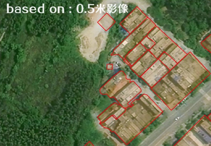
If you need a historical image map of the past or even the last century, you can use this product. Our company can provide historical image maps from 1960 to the present: the historical image maps from 1960 to 1980 were mainly 2-3 meters black and white satellite maps; From 1980 to 2000, the historical image map was mainly 15-30 meters; The historical image map from 2000 to 2015 is mainly 0.5-15 meters; After 2015, satellite images with a range of 0.3m-2m will be the main ones.


Resolution Samples

collected by WorldView4

0.3m

Houses&Trees
collected by superview

0.5m

Gymnasium
collected by GF2

0.8m

Town


collected by GF1

2m

Ndustrial Park
collected by RapidEye

5m

Airport
collected by Sentienl2A

10m

Chimney


Our Quality

北京亿景图高分辨率卫星影像数据查询系统

Professional Service

The global commercial optical remote sensing satellites include dozens of satellites from the United States, France, China and many other countries, and there are many kinds (high-resolution satellites, hyperspectral satellites, satellite radar data, etc.). BeiJing-OMAP has realized one-stop inquiry service to provide customers with the most accurate and detailed satellite image purchase service. At the same time, the company provides satellite remote sensing image data inquiry-satellite image purchase-image processing-after-sales one-stop service.

北京亿景图品牌广告登陆CCTV的证明牌匾

CCTV Exhibition Brand

CCTV represents the voice of China. In 2018, it even proposed to build a "national brand plan". BeiJing-OMAP passed the high-standard assessment of CCTV, and the brand advertisement successfully landed on CCTV, which was grandly broadcast to the whole country during the 7 prime time of the central government. It is a satellite image purchase service provider mainly engaged in high-resolution satellite map image data service with too few CCTV exhibitions.

北京亿景图的资质证书

Certified Quality

In 2017, BeiJing-OMAP successively obtained the computer software copyright and software product certificate double soft certification related to satellite remote sensing image, and in 2018 became a national high-tech enterprise with satellite image data service as its core. These honors are proof of our ability in satellite image service. At the same time, it is also the foundation for ensuring our service ability and service quality. We will continuously improve the service level and provide customers with better satellite image data services.


Application of satellite high frequency monitoring

【Satellite High Frequency Monitoring】

        In order to promote the application of low-and medium-resolution multispectral satellites, meet the needs of agriculture, water conservancy, forestry, land and disaster reduction and emergency departments for satellite high-frequency monitoring and rapid response in their respective jurisdictions, and give full play to the resource advantages and technical advantages of our company's high-resolution satellites, multispectral satellites and satellite radar data, our company has specially launched the scheme of "Satellite High-frequency Monitoring+Multi-use of One Map" for customers in various industries across the country. It can provide fixed-point satellite high-frequency monitoring and shooting service once a week (accumulated 5 times a month and accumulated about 60 times a year) for customers in various industries, and can be widely used for monitoring illegal phenomena, ecological environment changes, vegetation indexes and so on.。

美国DigitalGoble卫星正在采集卫星影像

Satellite Monitoring

Updated weekly

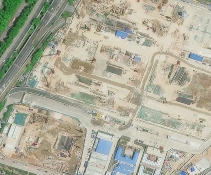
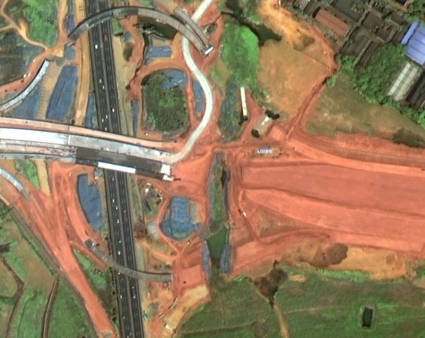
Satellite high-frequency monitoring can be used to quickly acquire the satellite map in 2021: in conventional projects, we take the cloud amount of satellite map less than 15% as qualified data, and under this standard, each monitoring area is expected to have 1-5 satellite map image data every month. In case of emergency disaster relief use scenario, we will provide monitoring results with maximum frequency in combination with satellite radar data (not affected by climate), and realize daily monitoring as soon as possible.

高光谱遥感卫星的使用方法

Image Analyse

Vegetation and Water

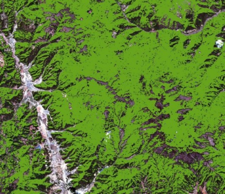
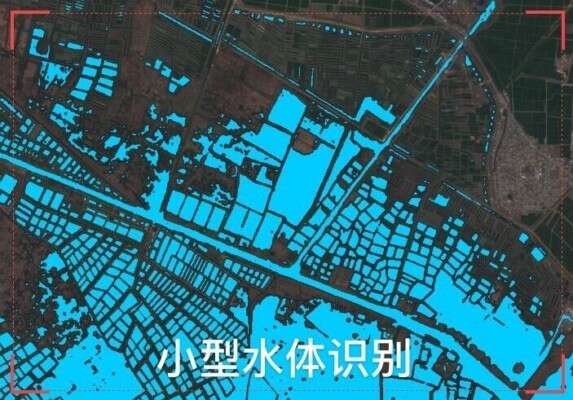
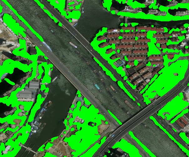
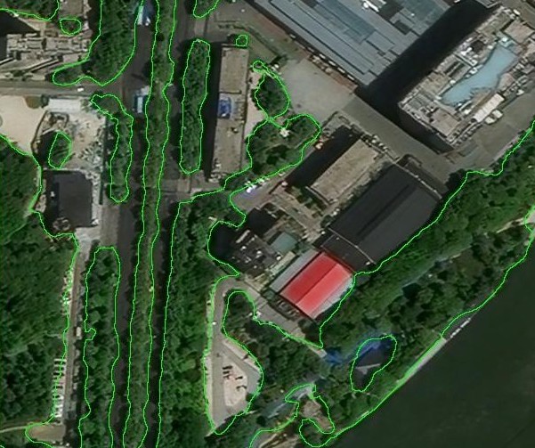
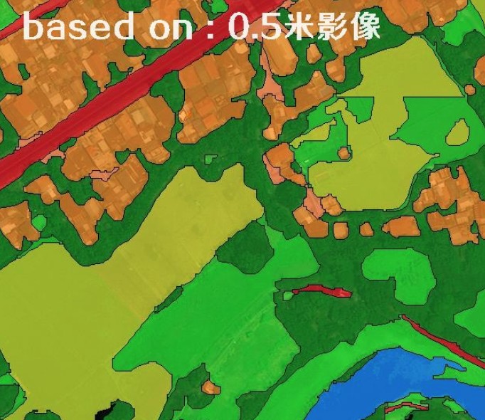
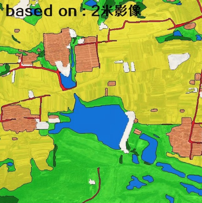
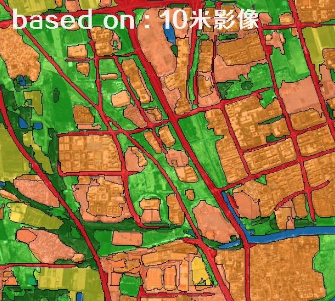
Hyperspectral satellites are rich in spectral information. On the basis of providing traditional satellite image data, we have standardized interpretation and analysis of remote sensing image data of each hyperspectral satellite, and the analysis results are displayed and provided in TIFF image format or picture format. Because the sensor type, spectral information and resolution of each hyperspectral satellite are different, the analysis results of each period are slightly different.

通过卫星图对比发现的城市变化

Changes Comparison

Urban Change

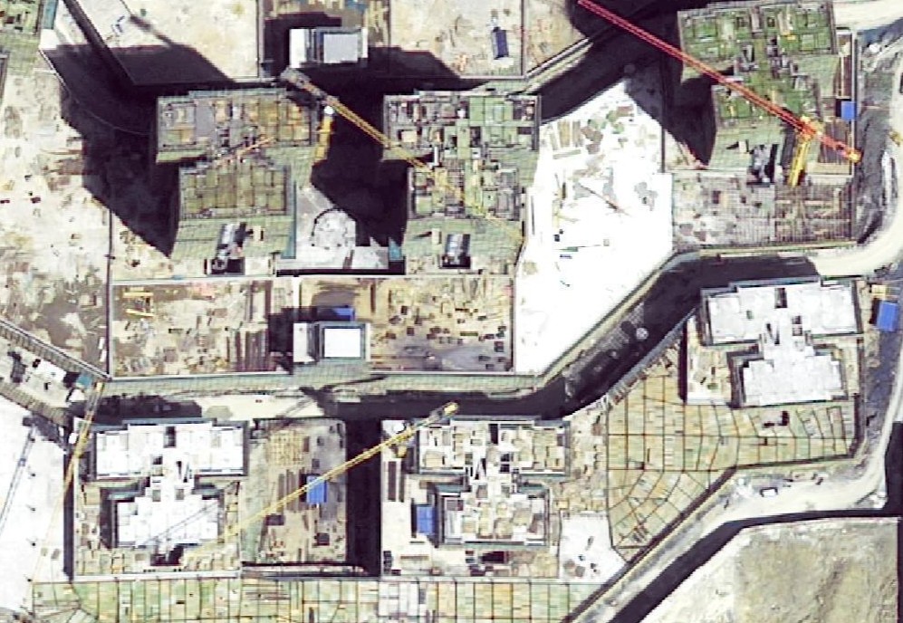
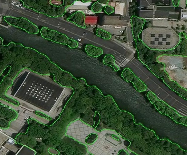
Through satellite high-frequency monitoring, the satellite map of 2021 is obtained once a month or even once a week, and then the multi-phase satellite images are compared and the change map spots are extracted, so that the changes of cities and landforms can be seen and seen accurately, which is mostly used for urban illegal construction, farmland protection, illegal forestry logging, park monitoring, urban greening monitoring, environmental protection supervision and so on.


01、Satellite Monitoring

哨兵2号卫星拍摄的10米分辨率水体卫星图

water

哨兵2号卫星拍摄的10米分辨率农业卫星图

farmland

哨兵2号卫星拍摄的10米分辨率城镇卫星图

Urban buildings


02、Image Analyse

基于10米哨兵2号卫星影像数据的农业光谱分析图

Agricultural analysis

基于10米哨兵2号卫星影像数据的林业光谱分析图

Forestry analysis

基于10米哨兵2号卫星影像数据的水利光谱分析图

Hydraulic analysis


03、Monitoring of Bare Soil Land

  • based on 0.3-1 meter spacial resolution satellite imagery data
  • used for monitoring of the bare soil area or bare land, such as construction site, road and bridge construction, mine exploitation, illegal excavation in the froest.

0.3-meter construction site

0.3-meter image

more>>
0.5-meter construction site

0.5-meter construction site

more>>
0.8-meter bare soil

0.8-meter bare soil

more>>


04、AI Recognizes Vegetation

  • based on 0.3-10 meter spatial resolution satellite imagery data.
  • AI automatic processing is adopted, so there may be some mistakes.
  • used for Extraction of urban greening range and Calculation of greening rate.
  • output data is in shapefile format, and can be used in ArcGIS.
  • Fast speed and low cost,support: production first, payment after.

AI recognizes vegetation based on 0.5m satellite image.

vegetation coverage

more>>
AI recognizes vegetation based on 0.5m satellite image.

trees found by AI

more>>
AI recognizes vegetation based on 0.5m satellite image.

trees found by AI

more>>


05、Automatic Classification of Landuse

  • based on 0.3-10 meter spatial satellite imagery data
  • AI automatic processing is adopted, so there may be some mistakes.
  • used for quickly make a large-scale and low-precision classification map of landuse status.
  • output data is in shapefile format with type attributes, and can be used in ArcGIS.
  • Fast speed and low cost,support: production first, payment after.

Automatic classification map of 0.5m images by AI

0.5m AI classification map

more>>
Automatic classification map of 2m images by AI

2m AI classification map

more>>
Automatic classification map of 10m images by AI

10m AI classification map

more>>


06、Automatic Identification of Buildings

  • based on 0.3-10 meter spatial satellite imagery data
  • AI automatic processing is adopted, so there may be some mistakes.
  • used for quickly acquire visible buildings within the target range.
  • output data is in shapefile format with type attributes, and can be used in ArcGIS.
  • Fast speed and low cost,support: production first, payment after.

recognized buildings  based on 0.3m image by AI

buildings found by AI

more>>
recognized buildings  based on 0.3m image by AI

buildings found by AI

more>>
recognized buildings  based on 0.5m image by AI

buildings found by AI

more>>


Leave Message & Requst Quotes